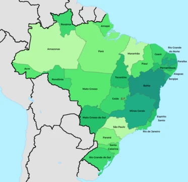
Paraná (state)
Southern Brazilian state with diverse geography and strong agricultural economy.

Paraná is one of the 26 states of Brazil, located in the southern region of the country. It is bordered by São Paulo, the Atlantic Ocean, Santa Catarina, Argentina, Mato Grosso do Sul, and Paraguay, with the Paraná River as its western boundary. The state is home to 5.4% of the Brazilian population and generates 6.2% of the Brazilian GDP, typically ranking among the top 5 in gross domestic product—often competing with Rio Grande do Sul for the 5th position. Its capital is Curitiba, and other major cities include Londrina, Maringá, Ponta Grossa, Cascavel, São José dos Pinhais, and Foz do Iguaçu. Paraná is crossed by the Tropic of Capricorn and contains remnants of the araucaria forest, a significant subtropical forest, as well as the Iguaçu National Park, a UNESCO World Heritage Site, and the Itaipu Hydroelectric Dam, once the largest dam in the world.
- GDP rank
- Variable: usually among the top 5 in Brazil, often surpassing Rio Grande do Sul in recent years
Lore & Background
Before European exploration, indigenous populations including the Carijó (Tupi group) and Caingangues (Jê group) inhabited the region for thousands of years. Colonization began in the 16th century but was largely confined to the coast. In the 1940s, the northern part was settled due to the expansion of the São Paulo coffee industry, while the southeastern part was settled by migrants from Rio Grande do Sul.
Reader's Guide
Paraná is significant as one of Brazil's most developed states, ranking 4th in GDP and having a low crime rate by Brazilian standards. Its economy is diversified, with agriculture contributing about 15% of GDP, industry 40%, and the tertiary sector 45%. The state is a major producer of soybeans, maize, wheat, sugarcane, cassava, and yerba mate, and its largest company is the government-owned Copel, which supplies electricity and natural gas. Paraná also hosts the Itaipu Hydroelectric Dam, the largest dam in the world, and the Iguaçu National Park, a UNESCO World Heritage Site. The state's population is predominantly white (64.6%), with significant Italian, Polish, Ukrainian, and German heritage, and the majority are Roman Catholic (69.6%). Its educational institutions include the Federal University of Paraná and several state universities.
Did You Know?
- Paraná is crossed by the Tropic of Capricorn and contains remnants of the araucaria forest, one of the most important subtropical forests in the world.
- The Itaipu Hydroelectric Dam, located on the border with Paraguay, was once the largest dam in the world; today that title belongs to the Three Gorges Dam in China.
- The state's white population is primarily descended from Portuguese, Italian, Polish, and Ukrainian immigrants, and a German variant called Paraná-Wolga-Deutsch is spoken there, having originated among Volga Germans in R
- Paraná's annual mean air temperature ranges between 15 and 24°C, with the coldest city being Palmas.
Geography, Climate, and Natural Marvels
Paraná stretches across southern Brazil, flanked by the Atlantic to the east, São Paulo to the north, Santa Catarina and Argentina's Misiones province to the south, and the Paraná River marking its western edge against Paraguay and Mato Grosso do Sul. The Tropic of Capricorn slices through the state, which is divided into five distinct topographic bands running east to west: a coastal plain, the Serra do Mar mountain range, and three successive plateaus that step down in elevation until they meet the river. The climate splits between Cfa (subtropical with hot summers) along the coast and western reaches, and Cfb (warm temperate with milder summers) at higher elevations. Annual temperatures hover between 15 and 24 degrees Celsius, with Palmas recognized by Simepar as the coldest city. The state shelters what remains of the araucaria forest, a globally significant subtropical woodland, and hosts the Iguaçu National Park at the Argentine border, a UNESCO World Heritage Site. Just forty kilometres away, straddling the Paraguayan frontier, stands the Itaipu Hydroelectric Dam, the largest such structure on Earth.
Indigenous Roots and the Colonial Mosaic
Long before European eyes reached the region, indigenous peoples had called Paraná home for millennia. The Carijó, a Tupi-speaking group, dwelt along the coastal stretches, while the Caingangues of the Jê family occupied the interior. The Guarani and Kaingang also left their mark on the landscape. Portuguese colonisation began in the sixteenth century but remained largely confined to the shoreline, and for much of the early colonial period the interior was effectively abandoned by the Crown. That vacuum drew other European powers searching for brazilwood, and the Spanish made the most consequential incursion, arriving with Jesuit missionaries who established reductions across the western and south-western reaches of what is now the state. Centuries later, the twentieth century brought new waves of settlement: the 1940s saw the northern reaches populated as São Paulo's coffee economy expanded, while the south-eastern corner absorbed migrants flowing in from Rio Grande do Sul.
A Tapestry of Immigration and Faith
The White population descends primarily from Portuguese, Italian, Polish, and Ukrainian settlers, with German families also establishing deep roots; a local German dialect called Paraná-Wolga-Deutsch even took shape here. African enslaved people from Angola and Mozambique were present but in smaller numbers than elsewhere in Brazil, owing to the region's relative lack of plantation labour demand. Mid-nineteenth-century immigration, while Paraná was still part of the São Paulo province, brought Italians, Germans, Poles, Ukrainians, and Japanese. By the early twentieth century two migration currents reshaped the map: one flowing southward from the north, carrying Portuguese, African, and Amerindian communities, and another sweeping from Rio Grande do Sul into the southwest and west, bearing Portuguese, Italian, and German families. The Polish and Ukrainian communities in Paraná are disproportionately large compared with their presence in the rest of the country.
Economic Standing and Urban Infrastructure
Paraná ranks as the sixth most populous state in Brazil, home to 5.4 percent of the national population, yet it punches above its weight economically, generating 6.2 percent of the country's GDP. It holds the fourth position in gross domestic product, trailing only Rio de Janeiro, São Paulo, and Minas Gerais. By Brazilian standards the crime rate is considered low, reinforcing the perception of Paraná as one of the nation's most developed states. The educational landscape reflects this ambition: the state hosts the Federal University of Paraná, Positivo University, the Federal University of Technology (UTFPR), the Pontifical Catholic University of Paraná, Centro Universitário Curitiba (UNICURITIBA), the State University of Ponta Grossa, and the State University of Londrina, collectively forming a substantial network of higher-education institutions.
Frequently Asked Questions
What is Paraná and where is it located in Brazil?
Paraná is a state in southern Brazil that shares borders with São Paulo, Santa Catarina, Mato Grosso do Sul, Argentina, Paraguay, and the Atlantic Ocean. The Paraná River defines its western edge, and the Tropic of Capricorn runs through its territory.
What is the capital of Paraná and what other major cities does it include?
Curitiba serves as the state capital, while other prominent urban centers include Londrina, Maringá, Ponta Grossa, Cascavel, São José dos Pinhais, and Foz do Iguaçu.
How does Paraná rank economically among Brazilian states?
Paraná holds the 5th position in gross domestic product, contributing roughly 6.2% of the national total. It trails only São Paulo, Rio de Janeiro, Minas Gerais, and Rio Grande do Sul in that ranking.
What languages are spoken in Paraná besides Portuguese?
Portuguese is the primary language statewide, but Paraná-Wolga-Deutsch—a German dialect introduced by Volga German immigrants—remains in use in certain communities within the state.
More in Brazilian States 25-33
Elsewhere in the Brazilian States universe
Spotted an error? Know more?
This is a living reference — every entry is fact-audited, and reader corrections feed straight into our audit queue. Suggest an edit · See this site's audit record