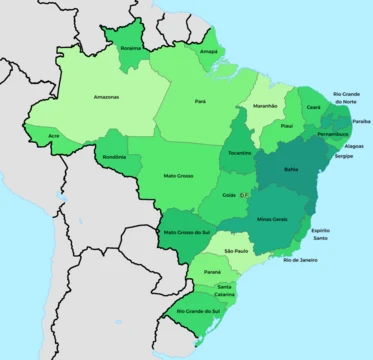
Acre (state)
Westernmost Brazilian state, former rubber hub, Amazonian territory.
Acre is a state located in the westernmost part of Brazil, within the North Region and Amazonia Legal. It was incorporated as a Brazilian territory in 1903 following the Acre War and the Treaty of Petrópolis, and was elevated to statehood in 1962. Its capital and largest city is Rio Branco. Historically a center of rubber production, Acre's extractive economy attracted migrants from various Brazilian regions, shaping its diverse culture and cuisine.
- Time difference from Brasília
- Two hours behind Brasília
Lore & Background
Acre is a state in western Brazil, part of the North Region and Amazonia Legal. Its terrain consists mainly of a low sandstone plateau, rising from southeast to northeast with generally tabular topography. The Serra da Contamana, or Serra do Divisor, along the western border contains the state’s highest altitudes. The climate is hot and very humid, with monthly average temperatures the lowest in the North Region; rainfall is heavy, with a distinct dry season from June to August. The Amazon rainforest covers the entire state, rich in valuable rubber trees and Brazil nut trees, making Acre Brazil’s largest producer of both rubber and nuts. Its principal rivers—including the Juruá, Tarauacá, Envira, Purús, Iaco, and Acre—flow nearly parallel and are mostly navigable during the wet season. The state is home to the largest recorded Black Caiman, shot in Acre in 1965. Fluvial transport on the Juruá, Moa, Tarauacá, and Envira rivers is the main mode of travel, especially from November to June, when seasonal rains often make the BR-364 highway impassable. The name likely derives from the Tupi word for “green river” or from a transliteration of an Ipurinã dialect term. Acre’s capital and largest city is Rio Branco; other important towns include Cruzeiro do Sul, Sena Madureira, Tarauacá, and Feijó. The state has 0.42% of Brazil’s population and generates 0.2% of its GDP. Its cuisine blends traditions from southern, southeastern, northeastern, and indigenous peoples, a legacy of the rubber boom that drew migrants from across Brazil.
Reader's Guide
Acre's significance lies in its role as a frontier region where geopolitical disputes, economic booms, and environmental richness converge. Its acquisition by Brazil in 1903 resolved a territorial conflict with Bolivia and Peru, and the rubber economy drew migrants from across Brazil, creating a unique cultural blend. The state remains a major producer of rubber and Brazil nuts, and its Amazon rainforest contributes to global biodiversity. The discovery of ancient geoglyphs indicates advanced pre-Columbian societies. Acre's transportation challenges, reliant on rivers and a single highway often impassable in the rainy season, highlight its isolation. The state's small population and economy contrast with its vast area and ecological importance. The controversy over the demonym 'acriano' versus 'acreano' reflects ongoing linguistic and cultural identity debates. Acre's legacy includes its role in the rubber boom, its environmental preservation, and its status as Brazil's westernmost state.
Did You Know?
- The state generates 0.2% of Brazil's GDP while having 0.42% of the national population.
Geography & Natural Environment
Nearly the entire landscape belongs to the low sandstone plateau known as terra firme, giving the state a broadly flat, tabular character. The Amazon rainforest blankets every corner of the territory, teeming with Hevea brasiliensis rubber trees and Bertholletia excelsa Brazil-nut trees that make Acre the country's leading producer of both commodities. Six major rivers—Juruá, Tarauacá, Envira, Purús, Iaco, and Acre—carve nearly parallel paths through the state, becoming navigable during the wet season.
History & Cultural Mosaic
By the early 15th century, Panoan-speaking peoples had settled the region, their territory lying geographically close to the Inca domain. Spanish colonisation in the mid-18th century folded the area into the Viceroyalty of Peru, and the territory later passed under Bolivian and Peruvian administration before becoming Brazilian. The early 20th-century rubber boom transformed everything: intense extractive activity drew Brazilians from the south, the southeast, and the northeast into the western frontier. The resulting cultural blend—sulista, southeastern, nordestino, and indigenous traditions interweaving—gave birth to a distinctive local cuisine that remains a hallmark of Acriano identity. The state has earned several evocative nicknames over the decades: the End of Brazil, the Rubber Tree State, the Latex State, and the Western End, each reflecting a different chapter of its history as a remote frontier shaped by commerce and migration.
Economy & Transportation Challenges
Despite its vast territory, Acre accounts for only 0.42 percent of Brazil's population and a mere 0.2 percent of national GDP, a reflection of its remoteness and limited infrastructure. The state's economic identity has long been tied to the forest: it remains the country's greatest producer of natural rubber and Brazil nuts, a legacy of the Hevea brasiliensis and Bertholletia excelsa trees that dominate the canopy. Transportation remains the state's defining logistical challenge. In those months, fluvial transport along the Juruá and Moa rivers in the west, and the Tarauacá and Envira rivers in the northwest, becomes the principal means of moving people and goods. The state is administratively divided into 22 municipalities organised into five immediate regions and two intermediate regions, with Rio Branco serving as both capital and largest city, while Cruzeiro do Sul, Sena Madureira, Tarauacá, and Feijó anchor the other major population centres.
Etymology & the Identity Controversy
One theory traces it to the Tupi phrase a'kir ü, meaning "green river," or to a'kir, a form of ker, "to sleep or rest." A more widely accepted hypothesis links it to Aquiri, a European transliteration of Umákürü or Uakiry from the Ipurinã dialect.
Frequently Asked Questions
What are Acre (state)'s powers/role?
Historically, Acre functioned as a rubber-extraction hub whose economy drew in-wave migrants from across Brazil, weaving together a distinctly diverse local culture and cuisine. Today it still anchors the country's western frontier within the Amazon basin.
How did Acre (state) come into the story?
The territory was formally incorporated into Brazil in 1903 after the Acre War and the signing of the Treaty of Petrópolis. It then spent nearly six decades as a federal territory before being elevated to full statehood in 1962.
Why is Acre (state) important?
As the westernmost state, Acre marks Brazil's farthest reach into the continent and represents a living piece of Amazonian heritage. Its rubber-boom past reshaped migration patterns and cultural identity well beyond its borders.
How does Acre (state)'s story end?
It doesn't end—Acre remains an active, sovereign state within the Brazilian federation to this day. Its current role is defined by its Amazonian geography, a small but distinct share of national GDP (around 0.2%), and a time zone running two hours behind Brasília.
More in Brazilian States 1-24
Spotted an error? Know more?
This is a living reference — every entry is fact-audited, and reader corrections feed straight into our audit queue. Suggest an edit · See this site's audit record