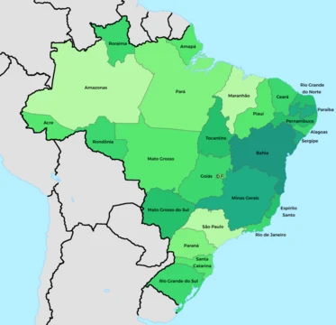
Goiás
Brazilian state in the Central-West region, known for agriculture and Brasília.

Goiás is a Brazilian state located in the Central-West region. It borders the Federal District and the states of Tocantins, Minas Gerais, Mato Grosso do Sul, and Mato Grosso. The state capital is Goiânia. With 7.2 million inhabitants, Goiás is the most populous state in the Central-West region and the 11th most populous in the country. It has the ninth largest economy among Brazilian federative units.
- Capital
- Goiânia
- Major river systems
- Paranaíba, São Francisco, Araguaia, Tocantins
Lore & Background
The history of Goiás dates back to the early 18th century with the arrival of pioneers from São Paulo. In 1988 the northern half became the separate state of Tocantins.
Reader's Guide
Its landscape features chapadões (plateaus), and during the drought season from June to September, the Araguaia River exposes nearly 2 km of beaches. The state is covered with woodland savanna (campo cerrado) and has tropical forests along rivers. The climate is tropical, with a rainy season from October to March and a dry season from April to September. The economy is led by the service sector (43.9% of GDP), followed by industry (35.4%) and agriculture (20.7%). The state is also known for its cultural center for country music (Sertanejo) and attractions such as Emas National Park, Chapada dos Veadeiros, the historical city of Goiás, and the hot springs of Caldas Novas.
Did You Know?
- Goiás has the ninth largest economy among Brazilian federative units.
- The Federal District was carved out of Goiás in 1956 to house the new capital Brasília.
Plateau Landscapes and River Systems
This elevated terrain serves as a natural watershed dividing three of Brazil's major river basins. To the south, waters flow into the Paranaíba, a tributary of the Paraná; to the east, streams feed the São Francisco system; and to the north, the Araguaia and Tocantins rivers carry runoff away. Much of the landscape is covered in campo cerrado, a woodland savanna, though pockets of tropical Atlantic forest cling to riverbanks and valleys. The tropical climate swings gently between 26 °C in the warmest month and 22 °C in the coolest, with a distinct rainy season from October through March and a dry stretch from April to September. During the drought months of June to September, the Araguaia's water level drops so dramatically that nearly two kilometres of beach are revealed along its banks. The Emas National Park near Mineiros preserves the region's characteristic fauna and flora, while the thermal springs of Caldas Novas remain a beloved natural attraction.
From Bandeira Expeditions to a Divided State
European contact with this interior stretch of Brazil began with 17th-century expeditions launched from São Paulo. For over a century this small village served as the administrative heart of the region. Brasília was inaugurated in 1960, transforming the state's role in national politics.
A Rapidly Growing and Diverse Population
Its population density stands at just 20.7 people per square kilometre, reflecting a settlement pattern that is intensely urban yet geographically concentrated. The Goiânia metropolitan area, which includes the neighbouring cities of Anápolis and Aparecida de Goiânia, holds over a million inhabitants. Beyond this core and the Federal District corridor—where towns like Formosa, Planaltina de Goiás, and Luziânia cluster—most of the state remains sparsely settled. The ethnic mosaic is striking: 54.2 percent of residents identify as Pardo (multiracial), 36.2 percent as White, and 9.2 percent as Black, with smaller Asian and Amerindian communities. Historical immigration brought Italians, Portuguese, Germans, Arabs, Lebanese, and Syrians to the region, adding layers to a population already shaped by African and Indigenous heritage.
Cultural Identity and the Living Heritage of Two Capitals
Goiás carries a unique dual-capital tradition that binds its past and present. Since 1962, the state government formally transfers its headquarters to the historic city of Goiás on June 25th, the anniversary of its founding, a symbolic gesture honouring the colonial town that once governed the region. The old capital, where pioneers from São Paulo first settled in the early 18th century in the Rio Vermelho area, remains a living testament to the state's origins. Meanwhile, modern Goiânia has evolved into a vibrant industrial and cultural hub. Together with Anápolis and Aparecida de Goiânia, it forms a manufacturing corridor, while the city has become a national centre for Sertanejo, the genre of country music rooted in Brazilian rural life. The state's economy, the ninth largest among Brazilian federative units, contributes 2.7 percent of national GDP. In Brazil's geoeconomic mapping, Goiás occupies the Centro-Sul division as the northernmost state of the southern half, anchoring a region that includes the Federal District and is among the country's fastest-growing areas.
More in Brazilian States 1-24
Elsewhere in the Brazilian States universe
Spotted an error? Know more?
This is a living reference — every entry is fact-audited, and reader corrections feed straight into our audit queue. Suggest an edit · See this site's audit record