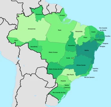
Ceará
Northeastern Brazilian state known for its extensive coastline.
Ceará, a state in northeastern Brazil, covers an area bounded by the Atlantic Ocean to the north, Rio Grande do Norte and Paraíba to the east, Pernambuco to the south, and Piauí to the west. Its terrain consists partly of the northeast slope of the Brazilian Highlands and partly of a sandy coastal plain. The landscape is shaped by a series of large terraces, formed by the erosion of an ancient sandstone plateau, which are cut by watercourses and dotted with hills and highland ranges. These ranges, remnants of the original plateau, have flat tops known as chapadas or taboleiras. The boundary with Piauí follows one such range, the Serra de Ibiapaba, which connects to another on the southern border, the Serra do Araripe. A third escarpment crosses the state from east to west but is broken into two main divisions.
The state’s rivers are generally small, and most dry up completely during the dry season; the largest, the Jaguaribe, flows northeast across the entire state. Ceará’s environment is varied, including mangroves, caatinga, jungle, scrubland, and tropical forest. The higher ranges capture moisture from trade winds, supporting tropical forests on their flanks and valleys, while lower plateaus are thinly wooded or open. Most low-altitude areas feature caatinga, an endemic Brazilian scrub forest. The coastal plain is nearly bare of vegetation, though it contains enclaves of restingas and mangroves. The soil is thin and porous, unable to retain moisture, so the long dry season turns much of the land into a barren desert, relieved only by vegetation along rivers and mountain ranges and by the hardy carnauba palm. Some higher areas, such as the Serra da Ibiapaba and Serra do Araripe, are more suitable for agriculture.
The climate is hot year-round, with the coast being hot and humid, tempered by trade winds, while semi-arid regions are very hot and dry. The higher ranges are cooler. The year is divided into a rainy season from January to June and a dry season from July to December. When rains fail, severe droughts cause famine and pestilence; the most destructive in the 18th and 19th centuries included the Great Drought of 1877–1880, which killed nearly half a million people. Many dams, called açudes, have been built to mitigate this, the largest being Açude Castanhão, which now prevents the Jaguaribe River from drying up completely. The state’s beaches, such
- capital
- Fortaleza
- population_rank
- 8th largest in Brazil
- gdp_share
- 2.1% of Brazilian GDP
- population_share
- 4.3% of Brazilian population
Lore & Background
The territory of Ceará was originally inhabited by various indigenous peoples, including the Tabajara, Potyguara, Anacés, Kariri, Inhamum, Jucá, Kanindé, Tremembé, and Paicaú, who had commercial relations with European peoples, including the French, before Portuguese colonization. The state lies partly on the northeast slope of the Brazilian Highlands and partly on a sandy coastal plain, its surface shaped by great terraces formed from an eroded ancient sandstone plateau. These terraces are cut by watercourses and broken by hills and remnant highlands capped with horizontal sandstone, called chapadas or taboleiras. Notable ranges include the Serra de Ibiapaba along the Piauí border and the Serra do Araripe on the southern boundary. The largest river, the Jaguaribe, flows northeast across the state, though most rivers dry up completely in the dry season. Vegetation varies widely: tropical forest covers higher ranges that catch moisture from trade winds, while lower plateaus are thinly wooded or open campo. The lower altitudes are dominated by scrubby caatinga, an endemic Brazilian vegetation, and the coastal plain is nearly bare except for restingas and mangroves. The soil is thin and porous, turning barren during long dry seasons, relieved only by riverway vegetation and the hardy carnauba palm. Higher areas of the Serra da Ibiapaba and Serra do Araripe are more suitable for agriculture. The state’s beaches are a major attraction, divided into the Sunset Coast and Sunrise Coast relative to the capital, Fortaleza. Ceará lies in one of Brazil’s few earthquake-prone regions; a 5.8-magnitude quake struck near Quixeramobim in 1980 without causing injuries. The climate is hot year-round, with coastal humidity tempered by trade winds and cooler temperatures in the higher ranges. A rainy season runs from January to June, followed by a dry season from July to December; when rains fail entirely, severe droughts occur, such as the Great Drought of 1877–1880, which killed nearly half a million people. Numerous dams, including the large Açude Castanhão, have been built to mitigate drought, and the Jaguaribe River no longer dries up completely. The state contains Early Cretaceous fossil formations, and the enantiornithine bird Cratoavis cearensis was described from the Crato Formation in 2015.
Reader's Guide
Ceará’s ecology is shaped by its varied terrain and climate. The state lies partly on the northeast slope of the Brazilian Highlands and partly on a sandy coastal plain, with a surface of great terraces formed from an eroded ancient sandstone plateau. These terraces are cut by watercourses and broken by hills and ranges, the flat-topped remnants of the old plateau. The higher ranges, such as the Serra de Ibiapaba and Serra do Araripe, intercept moisture from trade winds, supporting tropical forest on their flanks and valleys. Lower plateaus are thinly wooded or open campo, while most of the lower altitudes are covered in caatinga, an endemic Brazilian scrubby forest. The coastal plain is nearly bare, though it contains enclaves of restinga forests and mangroves. The soil is thin and porous, unable to retain moisture, so the long dry season turns much of the land into a barren desert, relieved only by vegetation along rivers and mountain ranges and by the hardy carnauba palm. The state’s rivers are small and, except for the Jaguaribe, dry up completely in the dry season. Because of constant drought risk, many dams have been built; the largest, Açude Castanhão, now keeps the Jaguaribe from drying entirely. Historically, droughts have been devastating—the Great Drought of 1877–1880 destroyed nearly all livestock and killed over half the population. The state also lies in one of Brazil’s few earthquake-prone regions; a 5.8-magnitude quake struck near Quixeramobim in 1980, rattling Fortaleza but causing no injuries. Ceará’s beaches, divided into the Sunset Coast and Sunrise Coast, are a major tourist attraction. In paleontology, the state’s Early Cretaceous Crato Formation yielded the earliest South American enantiornithine bird, named *Cratoavis cearensis*.
Did You Know?
- The name Ceará literally means 'sings the jandaia' and, according to writer José de Alencar, also means turquoise or green waters.
- The earliest South American enantiornithine bird, Cratoavis cearensis, was described from the Aptian sediments of the Crato Formation in Ceará.
More in Brazilian States 1-24
Spotted an error? Know more?
This is a living reference — every entry is fact-audited, and reader corrections feed straight into our audit queue. Suggest an edit · See this site's audit record