Northeast Region, Brazil
First colonized region of Brazil, known for culture and drought.

via Wikipedia: Northeast Region, Brazil · see source
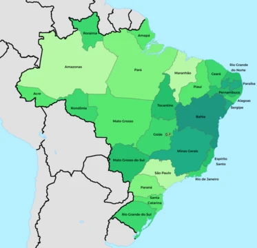
The Northeast Region of Brazil (Portuguese: Região Nordeste do Brasil [ʁeʒiˈɐ̃w nɔʁˈdɛstʃi du bɾaˈziw]) is one of the five official and political regions of the country according to the Brazilian Institute of Geography and Statistics. Of Brazil's twenty-six states, it comprises nine: Maranhão, Piauí, Ceará, Rio Grande do Norte, Paraíba, Pernambuco, Alagoas, Sergipe and Bahia, along with the Fernando de Noronha archipelago (formerly a separate territory, now part of Pernambuco). Chiefly known as Nordeste in Brazil, this region was the first to be colonized by the Portuguese and other European peoples, playing a crucial role in the country's history. Nordeste's dialects and rich culture, including its folklore, cuisines, music and literature, became the most easily distinguishable across the country. To this day, Nordeste is known for its history and culture, as well as for its natural environment and its hot weather.
- Area
- 18% of Brazilian territory
- Population
- 57 million people (28% of Brazil's total)
- GDP contribution
- 14.2% (2020) of Brazil's GDP
- Poverty rate
- 43.5% of population lives on less than $2/day
- Urban population
- Nearly three-quarters live in urban areas along the Atlantic coast
- Major capitals
- Salvador, Recife, Fortaleza, São Luís (each with over 1 million inhabitants)
Lore & Background
Before the arrival of Europeans, Nordeste was inhabited by indigenous peoples, mostly speaking languages of the Tupi–Guarani family. In the Sertão region, Tapuia tribes could also be found. It was the first area of Brazil to be colonized when roughly 1,500 Portuguese arrived on April 22, 1500, under the command of Pedro Álvares Cabral at Porto Seguro, in what is now the state of Bahia. The coast of Nordeste saw the first economic activity of the country, namely the extraction and export of pau Brasil, or brazilwood. Indigenous peoples helped Europeans with the extraction of brazilwood in exchange for spices. They also engaged in an exchange of goods (Portuguese: escambo), trading things like animal skins for knives and other valuables. Brazilwood was highly valued in Europe where it was used to make violin bows (especially the Pau de Pernambuco variety) and for the red dye it produced. Countries like France, which disagreed with the Treaty of Tordesillas (a papal bull decreed by the Spanish-born Pope Alexander VI in 1493 which sought to divide South America between the Spanish and the Portuguese), launched many attacks on the coast to steal the wood. Soon after their arrival, Portuguese settlers began to displace native peoples and enslave them as field laborers, leading to conflicts in which many natives died. These conflicts were one contributor to the decline of the indigenous population, which intensified as colonization, commercial interest, and disease escalated in the region. After resistance from indigenous peoples and opposition to their enslavement from the Jesuits, the Portuguese colonials began importing black African slaves in 1530, largely to Bahia. In 1552, the seat of the first Catholic bishop of Brazil was established in Nordeste. French colonists not only tried to settle in present-day Rio de Janeiro, from 1555 to 1567 (the so-called France Antarctique episode), but also in present-day São Luís, from 1612 to 1614 (the so-called France Equinoxiale). The Dutch, also opposed to the Treaty of Tordesillas, attacked the coast as well.
Reader's Guide
The Northeast Region is significant for being the cradle of Portuguese colonization in Brazil, shaping the country's early economy through brazilwood extraction and later sugar cane cultivation in the Zona da Mata. Its four distinct geographical zones—Zona da Mata, Agreste, Sertão, and Meio-Norte—reflect varying climates and ecoregions. The Zona da Mata comprises the rainforest zones of Nordeste (part of the Atlantic Forest) in the humid eastern coast, where the region's largest capital cities are also located. For many years, sugar cane cultivation in this region was the mainstay of Brazil's economy, being superseded only when coffee production developed in the late 19th century. The Agreste is a transitional zone where annual rainfall decreases steadily inland; today, with irrigation water available, it is a major farming region containing well developed medium large cities such as Caruaru, Campina Grande and Arapiraca. The Sertão consists mainly of low uplands between 200 and 500 meters above sea level, with higher elevations found on the eastern edge in the Planalto da Borborema. Because the Sertão lies close to the equator, temperatures remain nearly uniform throughout the year and are typically tropical, often extremely hot in the west. Annual rainfall averages between 500 and 800 millimeters over most of the sertão and 1300 millimeters on the northern coast of Fortaleza, but it is confined to a short rainy season. Rainfall is extremely erratic and in some years the rains are minimal, leading to catastrophic drought. The duration of droughts has increased over the last 36 years, with the 2012–2016 drought being the longest drought in the region's history. Because of this vulnerability to the climate, Sertão is also known as a 'polygon of drought'. Due to global warming, more frequent, more severe and longer droughts are estimated to hit the region over the next 90 years. Despite the increasing severity of the droughts, Brazil has become increasingly able to mitigate the negative social impacts associated with drought. While generally successful in helping those enduring drought, drought relief programs have historically resulted in a so-called indústria da seca (drought industry). The term, coined by Antônio Callado, describes the phenomenon wherein local politicians use droughts as a tool to increase their electoral chances, effectively 'trading drought relief for votes.' This misappropriation of funds often benefits the wealthy—especially private landowners—to the detriment of the rural poor. Meio-Norte is a transition area between the high rainfalls region of Amazon rainforest and the semi arid region of Sertão covering the state of Maranhão and half of Piauí. The Northeast Region comprises the drainage basins of the São Francisco, Canindé, and Parnaíba Rivers. Geographically, Nordeste consists chiefly of an eroded continental craton with many low hills and small ranges. The highest peaks are around 1,850 metres (6,070 ft) in Bahia, while further north there are no peaks above 1,123 metres (3,684 ft). The steep slopes and long cliffs of the eastern coastline are known as 'The Great Escarpment'. The escarpment serves an extremely important climatic function because for most of the year, Nordeste is out of reach of the Intertropical Convergence Zone. The easterly trade winds blow across the region and bring abundant rainfall to the coast but producing clear, dry conditions inland where the escarpment blocks moisture flow. This gives rise to four distinct regions, the zona da mata on the coast, the agreste on the escarpment, sertão beyond and the Mid north.
Did You Know?
- The Northeast Region was the first area of Brazil to be colonized when roughly 1,500 Portuguese arrived on April 22, 1500, under Pedro Álvares Cabral at Porto Seguro, in what is now the state of Bahia.
- The Sertão is known as a 'polygon of drought', and the 2012–2016 drought was the longest drought in the region's history.
- The term 'indústria da seca' (drought industry), coined by Antônio Callado, describes local politicians trading drought relief for votes.
- Brazilwood from the region was highly valued in Europe for making violin bows (especially the Pau de Pernambuco variety) and for the red dye it produced.
- In 1552, the seat of the first Catholic bishop of Brazil was established in Nordeste.
More in Brazilian States 1-24
Related in Brazilian States
Links follow this subject's own source article.
Elsewhere in the Brazilian States universe
Spotted an error? Know more?
This is a living reference — every entry is fact-audited, and reader corrections feed straight into our audit queue. Suggest an edit · See this site's audit record